This November's elections for the House of Representatives will be the first cycle to take place after decennial redistricting resulting from the 2010 census. As many observers of American politics will know, gerrymandering is a topic which infuriates many independents and partisans alike. Due to their historic gains in the 2010 elections in many states, Republicans were well positioned to exercise control over redistricting covering a large fraction of districts. In this diary, I take a look at how the implementation of non-partisan redistricting nationwide would impact the 2012 elections to the House of Representatives.
Several states already have independent commissions, or because they had split partisan control of the state government required a court to step in and draw the lines. For these states, such as California, I assumed no change to the maps since they were actually drawn independently. For the others, I've used Dave's Redistricting App to draw the lines, relying on uselectionatlas.org for political data and my own knowledge of local and regional politics from years of extensively following Daily Kos Elections (formerly Swing State Project).
Note: the maps I present are mainly used for analyzing the political impact of redistricting and as such I think they are quite realistic. You may disagree with some of the particular localities I've included with a certain district, but the goal was to put regions and communities of interest together. And of course, if you disagree with how I've drawn something, feel free to try drawing it yourself!
New Congressional Districts by Presidential Vote
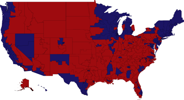
full size, customize-able png image here
For those of you who haven't seen it yet, here is the new map of congressional districts in place for the actual 2012 elections. See DKE's Complete Redistricting Resources for individual state maps. You can find election percentages for the districts here.
Control of Redistricting by Party
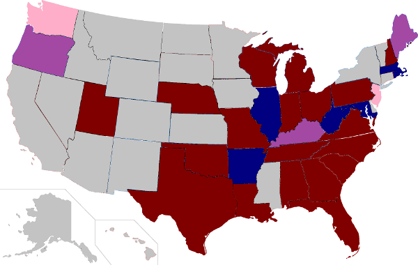
Dark Blue/Red - Democratic/Republican control
Light Red - Bipartisan Commission adopted GOP plan
Purple - Bipartisan Compromise
Gray - Independent Commission, Court-Drawn or At-Large
As should be immediately evident, Republicans control redistricting in far more states than Democrats. Below I'll present maps for all of the dark red and blue states. Additionally, I've included maps for Oregon and Kentucky which were compromise maps, as well as Washington state and New Jersey where Republicans were able to push through maps that were favorable to them. Let's get started.